The Looming La Niña: Unraveling the Global Impacts of the Shifting ENSO Cycle
Scientists and meteorologists are closely monitoring a critical phenomenon known as the El Niño-Southern Oscillation (ENSO). This complex interplay between the ocean and atmosphere in the Pacific Ocean has profound implications for global weather patterns, ecosystems, and economies. The current El Niño event, which has been influencing weather conditions worldwide, is expected to come to an end by late spring or early summer of 2024. We look into the anticipated transition from El Niño to a brief ENSO-neutral phase, followed by the potential onset of La Niña, and the cascading effects this shift may have on our planet.
The ENSO Cycle: A Delicate Balance
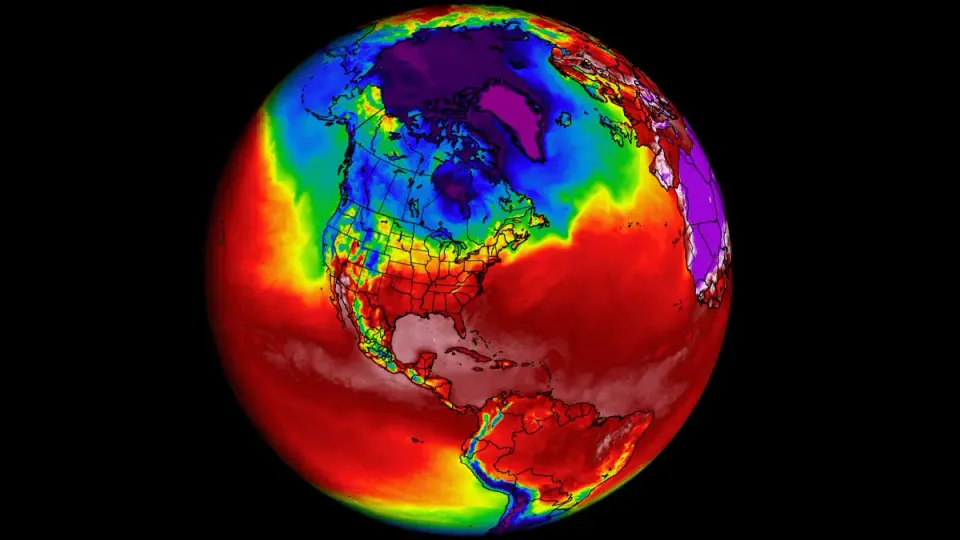
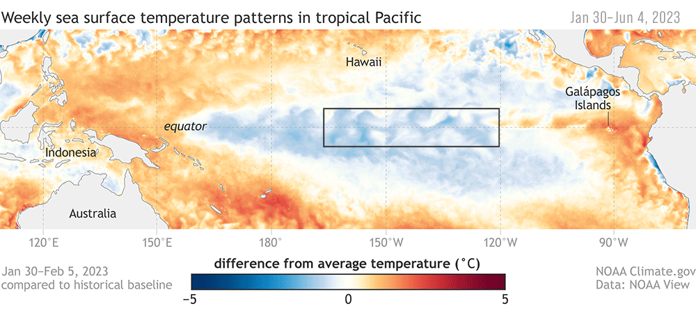
The ENSO cycle is characterized by fluctuations in ocean temperatures and atmospheric pressure across the equatorial Pacific Ocean. During an El Niño phase, the central and eastern Pacific experiences warmer-than-average sea surface temperatures, leading to significant changes in global weather patterns. Conversely, La Niña is marked by cooler-than-average sea surface temperatures in the same region, resulting in a distinct set of climate impacts.
The current El Niño event, which began in 2023, has been a dominant force in shaping global weather conditions. However, recent forecasts indicate that this warm phase is likely to dissipate by mid-2024, with a high probability of transitioning to ENSO-neutral conditions between April and June 2024. This neutral phase, characterized by near-average sea surface temperatures in the equatorial Pacific, is expected to be short-lived, as climate models suggest a 60% chance of La Niña developing between June and August 2024.
Factors Driving the Transition
The anticipated shift from El Niño to La Niña is driven by a complex interplay of oceanic and atmospheric processes. As the warm surface waters associated with El Niño begin to cool, the trade winds, which blow from east to west across the equatorial Pacific, strengthen. These reinforced trade winds promote the upwelling of cooler, nutrient-rich waters from the depths of the ocean, further cooling the surface and setting the stage for the development of La Niña conditions.
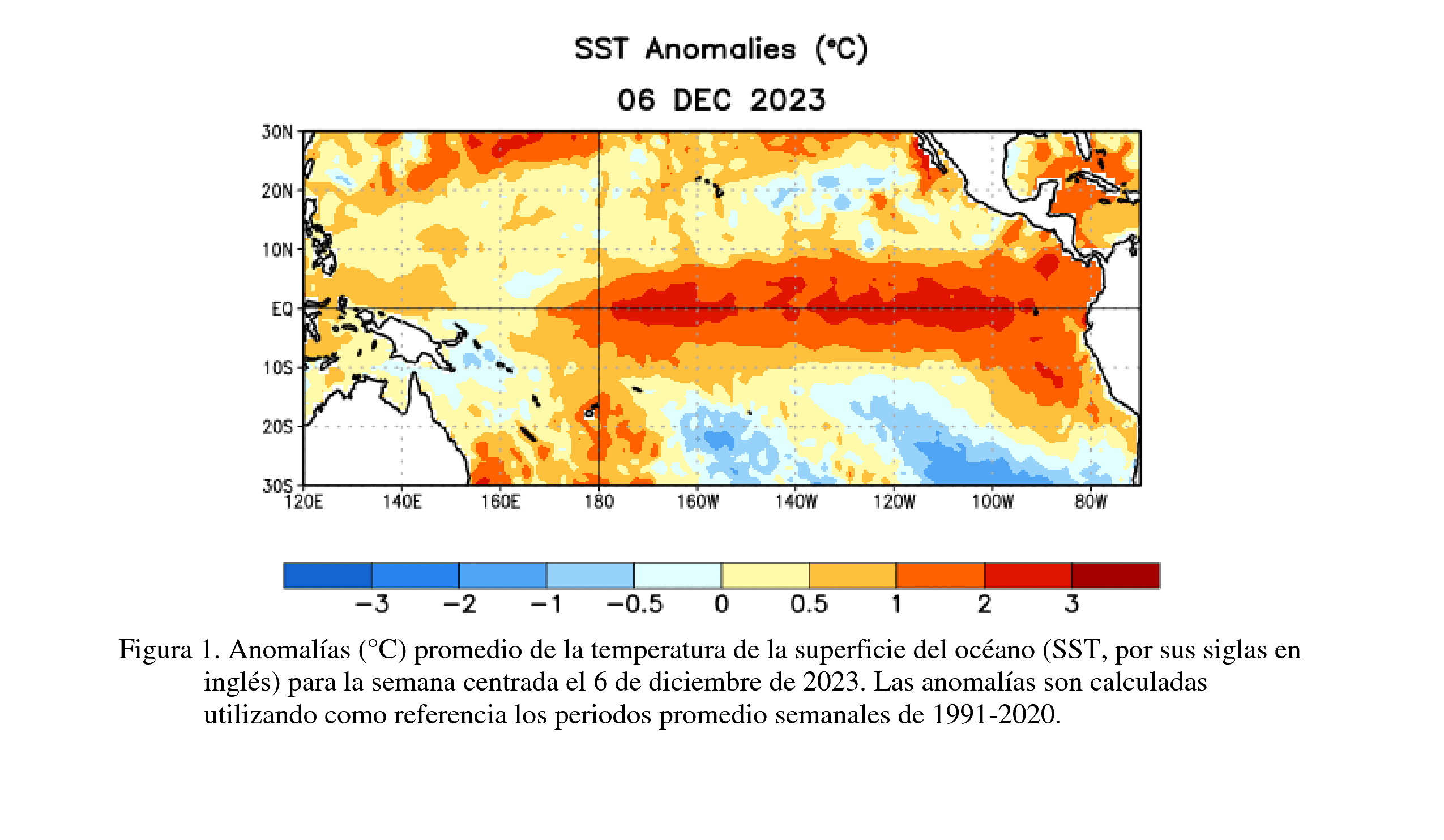
The cooling of the equatorial Pacific is not uniform, with certain regions experiencing more pronounced temperature changes than others. Climate scientists closely monitor key regions, such as the Niño 3.4 region in the central Pacific, to gauge the intensity and evolution of ENSO phases. The weakening of sea surface temperature anomalies across most of the equatorial Pacific Ocean is a strong indicator of the impending transition from El Niño to La Niña.
Global Impacts of the ENSO Transition
The shift from El Niño to La Niña has far-reaching consequences for global weather patterns, ecosystems, and human activities. During La Niña, the global climate tends to exhibit a distinct set of characteristics that differ from those observed during El Niño or ENSO-neutral conditions.
Weather Patterns
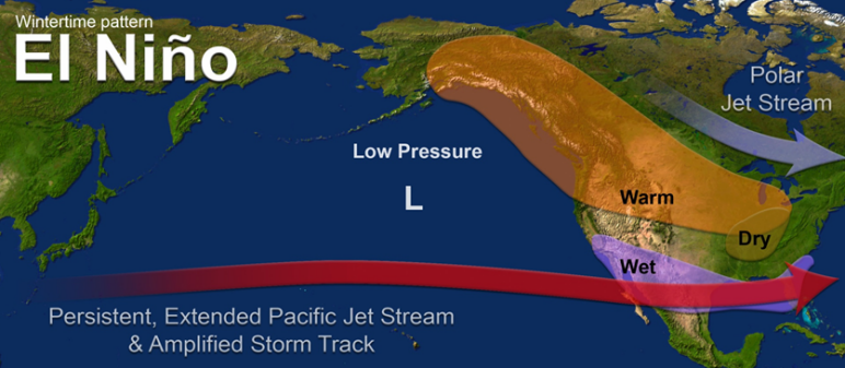
La Niña is known to significantly influence rainfall and temperature patterns across the globe. In the United States, La Niña typically brings drier conditions to the southern states, while the Pacific Northwest and Canada experience wetter weather. This shift in precipitation patterns can have implications for agriculture, water resource management, and wildfire risk.
In other parts of the world, La Niña can lead to increased rainfall in Southeast Asia, Australia, and northern South America, while causing drier conditions in parts of East Africa and the western Pacific. These changes in precipitation can affect crop yields, water availability, and the frequency of natural disasters such as floods and droughts.
Tropical Cyclone Activity
The ENSO cycle also plays a crucial role in shaping tropical cyclone activity worldwide. During La Niña years, the Atlantic hurricane season tends to be more active due to reduced wind shear over the Atlantic Ocean. Wind shear, which refers to the change in wind speed and direction with height, can hinder the development and intensification of tropical cyclones. With weaker wind shear during La Niña, conditions become more favorable for hurricane formation and strengthening.
Conversely, in the eastern Pacific, La Niña conditions tend to suppress tropical cyclone activity. This is due to the cooler sea surface temperatures and increased wind shear in the region, which create an environment less conducive to the development of tropical storms and hurricanes.
Ecosystem Impacts
The ENSO cycle has profound effects on marine and terrestrial ecosystems. During La Niña, the upwelling of cooler, nutrient-rich waters along the western coast of the Americas can lead to increased primary productivity in the ocean. This boost in nutrients supports the growth of phytoplankton, which form the base of the marine food web. As a result, La Niña years often see higher populations of fish, seabirds, and marine mammals in the eastern Pacific.
On land, the shifts in precipitation patterns associated with La Niña can alter the distribution and abundance of vegetation. In regions experiencing increased rainfall, such as northern Australia and Southeast Asia, vegetation growth may be enhanced, providing favorable conditions for certain plant and animal species. Conversely, in areas facing drier conditions, such as parts of the southern United States, vegetation may be stressed, leading to potential impacts on wildlife and ecosystem health.
Economic Consequences
The ENSO cycle can have significant economic implications, particularly for industries that are sensitive to weather conditions. Agriculture, energy, and tourism are among the sectors most affected by the shifts in weather patterns associated with El Niño and La Niña.
During La Niña years, the altered precipitation patterns can impact crop yields and agricultural productivity. Regions experiencing drier conditions may face challenges in meeting irrigation demands, while areas with increased rainfall may grapple with flooding and soil erosion. These changes can affect food prices, agricultural exports, and the livelihoods of farmers and rural communities.
The energy sector is also influenced by the ENSO cycle. La Niña conditions can lead to increased demand for heating in regions experiencing colder temperatures, while areas with milder winters may see reduced energy consumption. Additionally, the shifts in precipitation patterns can affect hydropower generation, as well as the availability of water for cooling in thermal power plants.
Tourism, particularly in coastal regions, can be impacted by the changes in weather patterns and tropical cyclone activity associated with La Niña. Coastal destinations may experience changes in beach erosion, water quality, and the health of coral reefs, which can affect their attractiveness to tourists. Moreover, the increased risk of tropical cyclones in certain regions during La Niña years can disrupt travel plans and impact tourism revenue.
Monitoring and Forecasting the ENSO Transition
Given the wide-ranging impacts of the ENSO cycle, accurate monitoring and forecasting of the transition from El Niño to La Niña are crucial for informed decision-making and preparedness. Climate scientists and meteorological agencies worldwide employ a suite of tools and techniques to track the evolution of ENSO conditions.
Satellite observations, ocean buoys, and climate models are among the key tools used to monitor and predict ENSO phases. Satellite data provide valuable insights into sea surface temperatures, wind patterns, and atmospheric moisture, while ocean buoys collect in-situ measurements of temperature, salinity, and currents. Climate models, which simulate the complex interactions between the ocean and atmosphere, are used to generate probabilistic forecasts of ENSO conditions several months in advance.
The National Oceanic and Atmospheric Administration (NOAA) and other meteorological agencies issue regular ENSO updates and outlooks to keep stakeholders informed about the current state and anticipated evolution of the ENSO cycle. These forecasts are essential for sectors such as agriculture, water resource management, and disaster preparedness, allowing them to make informed decisions and adapt to the expected impacts of El Niño or La Niña.
Conclusion: Mitigate Risks & Capitalize On Opportunities
As the world braces for the potential onset of La Niña in the latter half of 2024, it is crucial to understand the far-reaching implications of this shift in the ENSO cycle. The transition from El Niño to La Niña is a complex process driven by the intricate interplay between the ocean and atmosphere, with cascading effects on global weather patterns, ecosystems, and human activities.
By closely monitoring the evolving ENSO conditions and leveraging the power of climate models and observational tools, scientists and decision-makers can better anticipate and prepare for the impacts of La Niña. From adapting agricultural practices and water management strategies to bolstering disaster preparedness and resilience, proactive measures informed by accurate ENSO forecasts can help mitigate the risks and capitalize on the opportunities associated with this global climate phenomenon.


Member discussion